


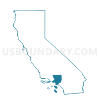
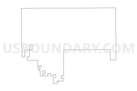
Voting District 56510, Los Angeles County, California
About
Outline

Summary
| Unique Area Identifier | 534270 |
| Name | Voting District 56510 |
| County | Los Angeles County |
| State | California |
| Area (square miles) | 44.06 |
| Land Area (square miles) | 43.99 |
| Water Area (square miles) | 0.07 |
| % of Land Area | 99.85 |
| % of Water Area | 0.15 |
| Latitude of the Internal Point | 34.78015240 |
| Longtitude of the Internal Point | -118.24615710 |
Maps


Graphs
Select a template below for downloading or customizing gragh for Voting District 56510, Los Angeles County, California


Neighbors
Neighoring Voting District (by Name) Neighboring Voting District on the Map
- Voting District 20000, Kern County, CA
- Voting District 20675, Kern County, CA
- Voting District 20680, Kern County, CA
- Voting District 20685, Kern County, CA
- Voting District 20855, Kern County, CA
- Voting District 56513, Los Angeles County, CA
- Voting District 56516, Los Angeles County, CA
- Voting District 56531, Los Angeles County, CA
- Voting District 56624, Los Angeles County, CA
- Voting District 56630, Los Angeles County, CA
Top 10 Neighboring County Subdivision (by Population) Neighboring County Subdivision on the Map
Top 10 Neighboring Place (by Population) Neighboring Place on the Map
Top 10 Neighboring Elementary School District (by Population) Neighboring Elementary School District on the Map
- Lancaster Elementary School District, CA (112,669)
- Westside Union Elementary School District, CA (69,586)
Top 10 Neighboring Secondary School District (by Population) Neighboring Secondary School District on the Map
Top 10 Neighboring Unified School District (by Population) Neighboring Unified School District on the Map
Top 10 Neighboring State Legislative District Lower Chamber (by Population) Neighboring State Legislative District Lower Chamber on the Map
- Assembly District 36, CA (584,284)
- Assembly District 34, CA (487,193)
- Assembly District 37, CA (459,802)
Top 10 Neighboring State Legislative District Upper Chamber (by Population) Neighboring State Legislative District Upper Chamber on the Map
Top 10 Neighboring 111th Congressional District (by Population) Neighboring 111th Congressional District on the Map
Top 10 Neighboring Census Tract (by Population) Neighboring Census Tract on the Map
- Census Tract 55.06, Kern County, CA (5,998)
- Census Tract 9009, Los Angeles County, CA (3,813)
- Census Tract 9012.09, Los Angeles County, CA (1,633)